Our Services
SERVICES
Land Survey
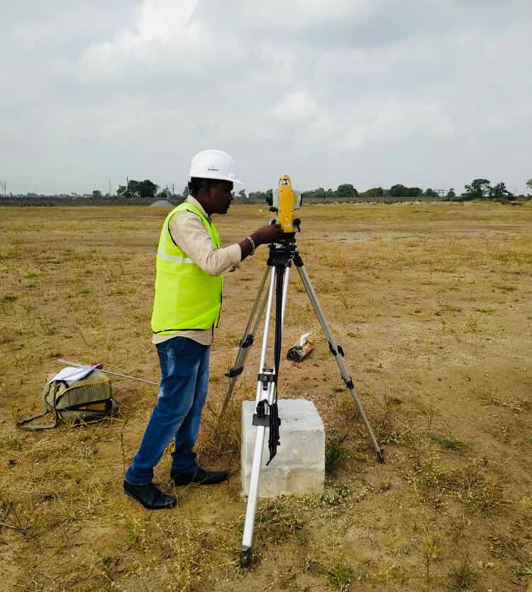
Land surveying is the technique, profession, and science of accurately determining the terrestrial or three-dimensional position of points and the distances and angles between them, commonly practiced by licensed surveyors, and members of various building professions. These points are usually on the surface of the Earth, and they are often used to establish land maps and boundaries for ownership, locations (building corners, surface location of subsurface features) or other governmentally required or civil law purposes (property sales).
Land surveying is the detailed study or inspection, as by gathering information through observations, measurements in the field, questionnaires, or research of legal instruments, and data analysis in the support of planning, designing, and establishing of property boundaries.
Stakeout Survey
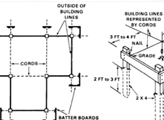
In order to begin excavation of trenches required for a building's foundation, the builder must know the positions and levels of building lines shown on the construction plans on the ground.That is, the exact length, width, depth, and position of the foundation trenches must be marked on the ground.
This movement from the construction plan to the actual site by transferring dimensions from the layout plan to the ground is called setting out. It is probably the most critical step in the entire construction process.
Topographical Survey
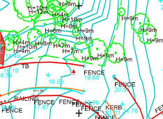
determining the relative locations of points (places) on the earth's surface by measuring horizontal distances, differences in elevation and directions topos (Gr.): place; topographic maps give the locations of places (observable features); they serve as base maps
A Topographic Survey is a survey that gathers data about the elevation of points on a piece of land and presents them as contour lines on a plot. The purpose of a topographic survey is to collect survey data about the natural and man-made features of the land, as well as its elevations.

Road Survey
Highway surveying is a specialized type of land surveying generally conducted for government agencies during the planning stages of a highway development project. During the construction process, a highway construction survey can ensure that progress is occurring as it should, and that the highway is located precisely where it should be. After the highway is built, a highway survey can be used to provide an accurate layout of roadways, utilities, storm drainage systems, overhead wires, nearby buildings, and other features of the landscape.
A construction surveyor is often involved in the placement process for the highway. This requires a survey of the existing terrain to find the best route. Highway construction surveys are particularly concerned with areas where dirt must be moved, noting to what level and grade. Often the goal of this survey is to determine the appropriate route where the least amount of land will need to be moved. An engineer can use the survey data to determine where the dirt should be moved to reduce the total amount of dirt relocation.

Railway Line Survey
The Railway Line Survey is an extensive study of an entire area that might be used for a road or airfield. Its purpose is to eliminate those routes or sites which are impractical or unfeasible and to identify the more promising routes or sites. Existing maps and aerial photographs may be of great help.
To construct anything haphazardly is not engineering. Prior to survey the available maps of proposed area are studied. This helps in fixing suitable alignment facilitate various surveys work.

Water bodies Survey
Surveys of water bodies are used for covering cables and pipes and for drawing up as-built documentation. They serve as a basis for hydrostatic calculations and for extensive tests of water bodies for creating digital terrain models. Our two frequency echo sounding device enables us to collect data about the soil properties (layers of mud) and the depths of the waters in the water bodies. This data can be converted into and supplied in all CAD systems. Various systems are used in our company including Geograf, Card 1, Microstation and Autocad.

Quantity Survey
A quantity surveyor (QS) is a construction industry professional with expert knowledge on construction costs and contracts. Qualified professional quantity surveyors are also known as Chartered Surveyors (members and Fellows of RICS) in the UK.
Our two frequency echo sounding device enables us to collect data about the soil properties (layers of mud) and the depths of the waters in the water bodies. Quantity surveyors are responsible for managing all aspects of the contractual and financial side of construction projects. Quantity surveyors manage the costs on a construction project. They help to ensure that the construction project is completed within its projected budget.
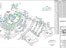
As Built Survey
The purpose of the As-Built Survey – also commonly called a Physical Survey – is to show the property “as it is built” at a particular point in time. While a pre-construction survey is performed to document conditions prior to construction work being performed, the As-Built survey is conducted to show the current state of the site at various stages throughout the duration of a project. It also serves as a close-out document to verify that the work authorized was completed to plans and in compliance with all relevant standards and regulations. An As-built survey builds upon the base map of a project and includes research at local agencies, ground-level topography data, and the documentation of visible site improvements. The advantage of this survey is that the new Base Map can be updated to show the current conditions of the site.

Cadd Services
CAD Services is widely used in the AEC industry for the creation of 2D drawings or 3D models. Unlike a manual design and drafting process, Computer Aided Design (CAD) systems can maintain a database of building parts and construction-related knowledge and standards which also provides a far higher standard of precision and ease of modification of designs. Designs can be easily shared, enabling collaboration between the different experts and agencies involved. The different kinds of drawings and files that are required by all the different contractors can be easily generated and shared from CAD designs, there is no dependency on a draftsman. AEC professionals use CAD drawings and models to see all aspects of the project, fix problems, and give clients a virtual tour.
UAV-Drone Survey
SK CIVIL SURVEYS, a leading India based service provider of land surveying, aerial surveying and all types of aerial photography and video for commercial advertising, display, marketing and domestic applications. We expertise in proficient aerial photography services with innovative sensor technologies in the areas of Drone, UAV survey India, mapping, GIS surveying, topographical survey, 3D mapping survey, photogrammetry consultancy, drone inspection in railway/roads, aerial infrastructure monitoring, mining services, rural automatons, vegetation mapping, crop health monitoring as well as aerial filming and aerial photography services. Our UAV system independently covers expansive zones to catch high determination information in visible or Near infrared spectrum for producing highly detailed and accurate orthophotos, 3D Digital Elevation Models and topographic data.
Aerial Photography
We offer Aerial Photography by using drones in Business advancements, Real estate, Special events like Sports or any memorable occasions. Here we offer Aerial Drone Photography/Videography that is second to none. We digitize the real world for business and government. From huge spans of scenery down to individual pieces of machinery, we capture everything. Our depth of resources provides the flexibility to adapt our methods to specific project needs. We then help our clients manipulate it, analyze it, and profit from it. Get in touch with us for any of your airborne photography needs.
Orthomosaic and Recording
Drones are increasingly using thermal imagery to provide high-value deliverables to clients. We SK CIVIL SURVEYS having drones provides the opportunity to have high resolution single images or multiple images stitched together to create an "orthomosaic". These images are georeferenced so when used in other applications such as GIS they are in their correct location. Orthomosaic maps are created from data flights that capture numerous images and their associated data. The images are processed post flight to produce a georeferenced map that is current to the day it was flown.
Photogrammetry
A valuable and novel application of photogrammetry is the creation of 2D/3D models. We offer 2D/3D modeling surveys using photogrammetry which is the process of authoring high-quality, reusable, and game-ready digital assets, by using multiple photos of the original real-world objects. Photogrammetry can be classified several ways. It’s best suited to objects that are time-consuming to produce in 2D/3D sculpting software. It produces very high-quality geometry and textures. Photogrammetry is used in fields such as topographic mapping, architecture, engineering, manufacturing, quality control, police investigation, and geology. Archaeologists use it to quickly produce plans of large or complex sites and meteorologists use it to determine the wind speed of tornados when objective weather data cannot be obtained. Photogrammetry services in India are also commonly employed in collision engineering, especially with automobiles.
DGPS SURVEY
DGPS stands for Differential global positioning system. DGPS is widely used in surveying applications like recording of points , setting up of ground control points, staking out, and various other applications. DGPS is based on satellite technology. it determines its positions from the relative location of other satellites . It provides Northing , Easting and Elevation of any point on the surface of earth , provided the receiver is connected to a minimum of four satellites. There are a lot of corrections which the DGPS takes care of depending on the nature of atmosphere, wind, pollution, humidity etc.
Methods of Survey
RTK (Real time Kinematic)
This is the most used type of survey using DGPS. In this the corrections will be real time and the user can see the corrected values of coordinates instantly. Further , there is no need for processing the data in the office and can be directly used for field applications. It provides a positional accuracy of Horizontal: 8mm + 1ppm RMS & Vertical:15mm + 1ppm RMS which suffices for most of the construction industry. This can be done either with the help of Radio (which is banned in India ) or by the help of a server setup. SK CIVIL SURVEYS has a server set up , which can cater to recording of points for up to 25 km from the base station.
Static Survey
This is used for setting up control points and benchmarks . In this technique, the GPS receiver is set up over a point for about 45 minutes to an hour. We can achieve an accuracy of 1 mm with this technique. This is mainly used to set up the control network. SK CIVIL SURVEYS has successfully set up the control network for Many Projects in India.
PPK(Post processing Kinematic)
In this method , the survey is done without the use of either the radio or server. The data has an accuracy of about 2 to 3 meters, and, when the data is processed in software like Trimble business center, we get accuracy to the level of 2 cm.
Apart from these DGPS is also being used in the following sectors:
- Topographical Survey
- Railway Line Survey
- Drone Control Point Survey
- Waterbodies Survey
- River, Canal Survey
- Pipeline survey
- Solar Panel Setup Survey
- Mining Survey
- Forest Clearance etc.